
THE EASTERN SLOPES COAL CORRIDOR
FROM THE YUKON SHADOW TO THE U.S. BORDER

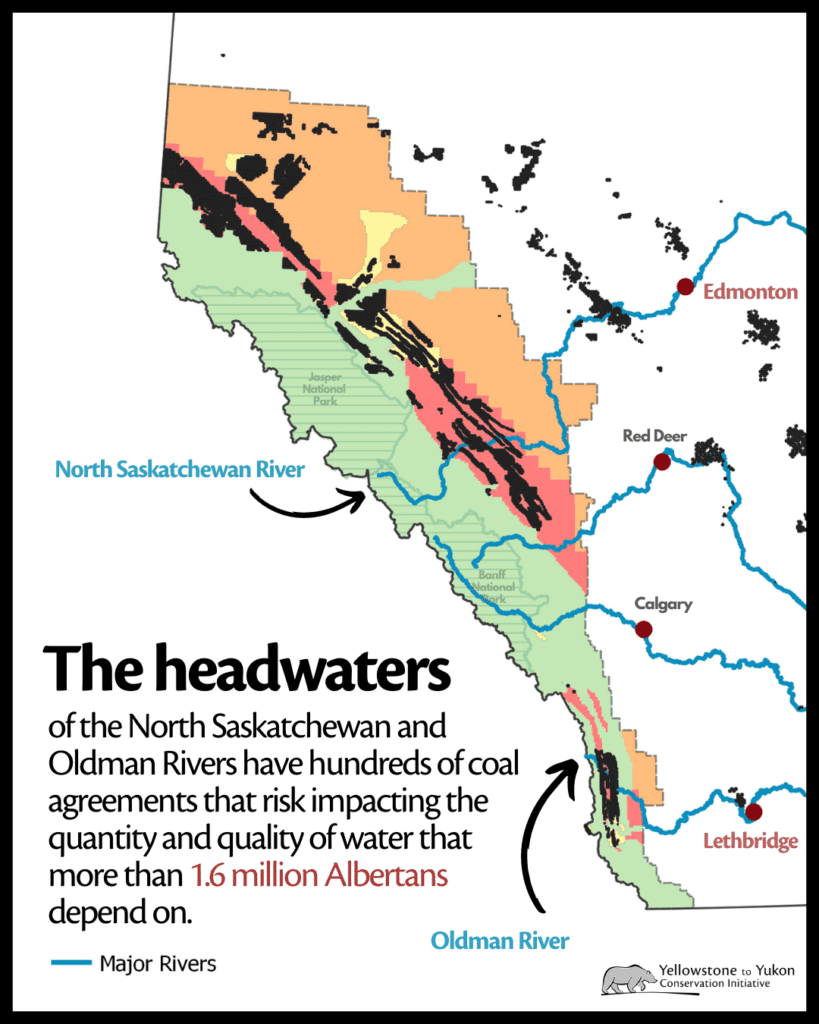
The Real Map Is Not a Mine Map. It Is a Water Map.
The proper way to understand Alberta coal is not by starting with Grassy Mountain. That is the political decoy. The proper way is to start at the top of the province and trace the Rockies and foothills southward, watershed by watershed, until the whole pattern appears. What emerges is not one mine, one company, or one controversy. It is a long industrial temptation running down the eastern face of the mountains, from the northern coal fields near Grande Cache and the Smoky–Athabasca system, through the North Saskatchewan and Red Deer headwaters west of Rocky Mountain House, down into the Oldman and Crowsnest systems at the U.S. border. That corridor overlaps the source region of Alberta’s water, wildlife, grazing land, recreation economy, Indigenous land relationships, and municipal drinking-water systems. The danger is not simply that one project might fail. The danger is cumulative: many projects, many leases, many access roads, many exploration cuts, many rail-export dreams, and many separate regulatory files pretending they are not part of one provincial-scale transformation.
The Northern Corridor: Grande Cache, Smoky River, Athabasca Headwaters
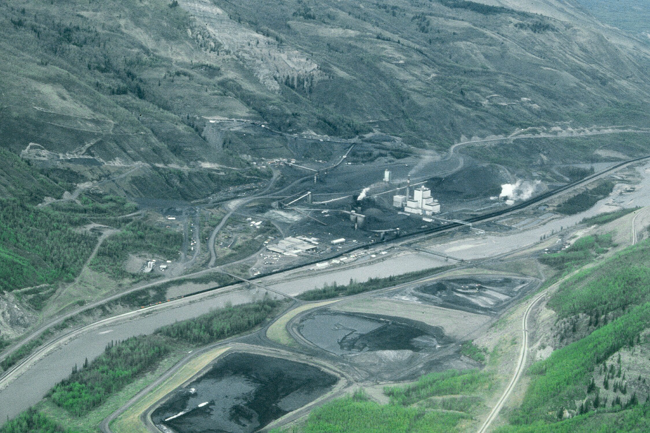
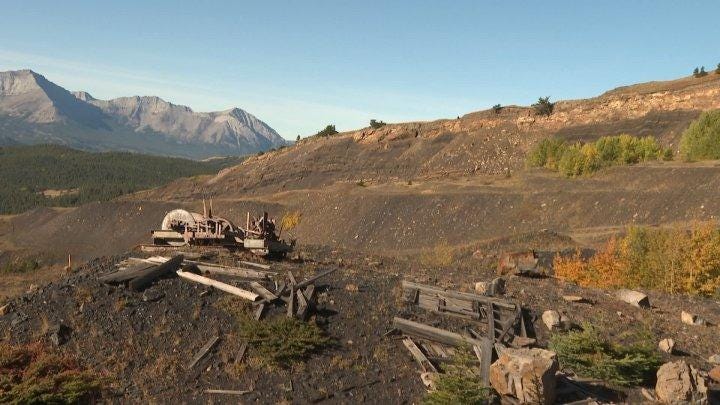
The northern end of the corridor begins around Grande Cache and the upper Smoky River country, where coal is already part of the industrial landscape. This region is often left out of the public debate because it is farther from Calgary and Edmonton’s media imagination, but hydrologically it matters enormously. The Smoky River flows into the Peace River system; the Athabasca headwaters and nearby mountain tributaries feed one of Alberta’s great northern water arteries. Here, the issue is not just new controversy but legacy normalization. Once coal mining is treated as ordinary in one mountain watershed, the political argument can migrate south: if it is acceptable there, why not here, and then why not everywhere else? CPAWS notes that Alberta’s Eastern Slopes contain hundreds of thousands of coal leases and include active coal mining areas such as Grande Cache, Coal Valley, and Vista.
The West-Central Corridor: Nordegg, Bighorn, Ram River, Clearwater
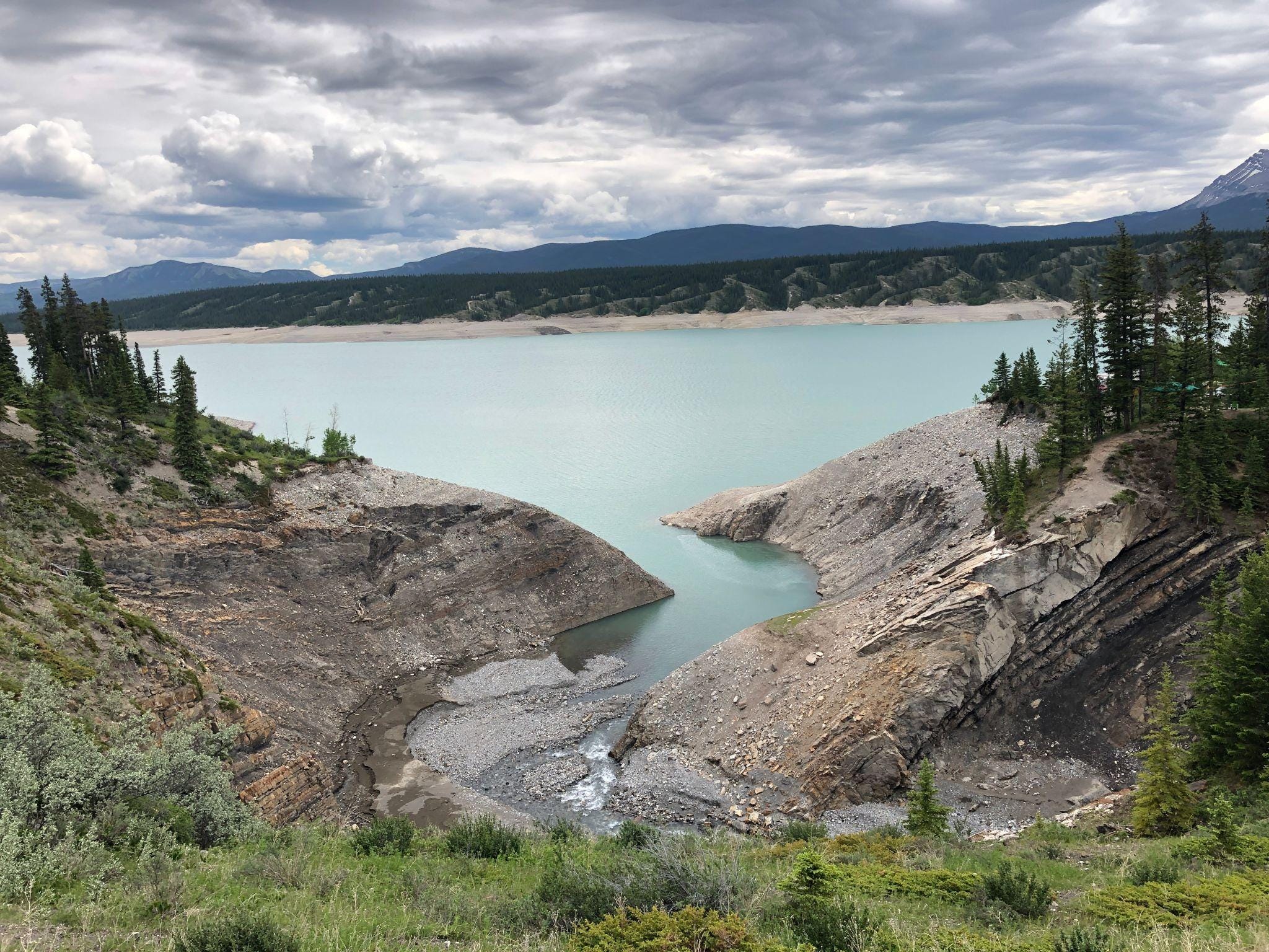
This is the hidden heart of what you are pointing to. West of Rocky Mountain House, around Nordegg, Bighorn, Ram River, Clearwater River, Blackstone, Aries, and the surrounding lease blocks, the coal question becomes a direct threat narrative for central Alberta. These are not remote abstractions. They sit among tributaries, campgrounds, protected areas, recreation corridors, and headwater systems tied to the North Saskatchewan and Red Deer basins. The AER’s own coal map infrastructure confirms that coal mine and lease information is mapped across the province, while the Alberta government’s own coal engagement materials acknowledge that Eastern Slopes restrictions and planning remain central unresolved issues.
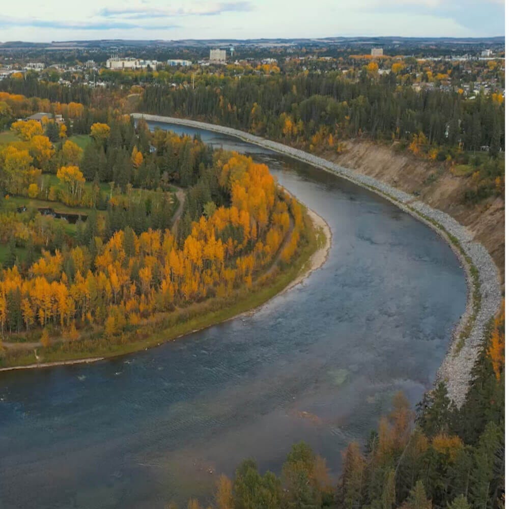
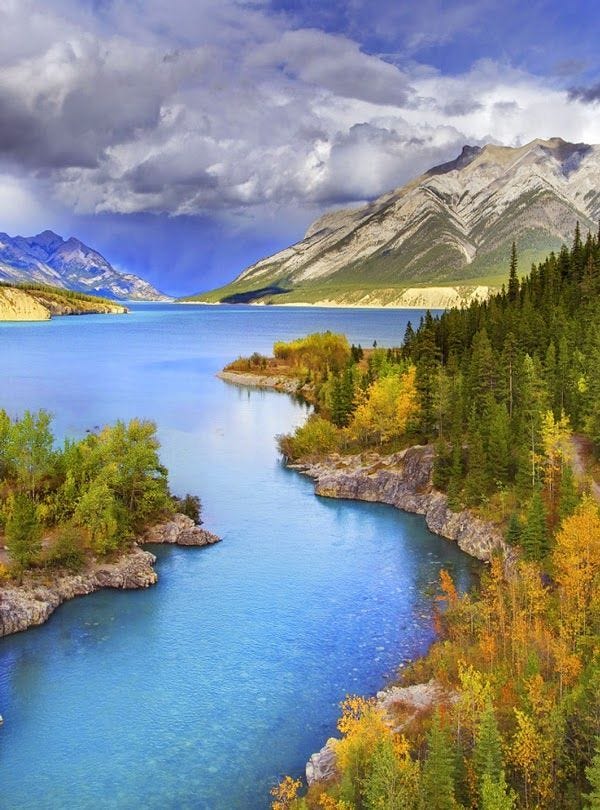
The North Saskatchewan River is the artery that makes this politically explosive. Edmonton does not drink from a theory. It drinks from a river system born in the mountains. When coal leases and proposed projects sit around tributaries feeding that system, no government can honestly say downstream communities have no stake. The correct question is not whether a company promises modern mitigation. The correct question is whether Alberta is willing to gamble a drinking-water source region for export coal moving by rail to tidewater.
The Red Deer–Sundre–Drumheller Corridor
Move south and east through the Red Deer River watershed, and the same pattern repeats. Sundre, Caroline, the Red Deer River, and eventually Drumheller are connected through water long before they are connected through politics. Coal leases in Category 2 lands within the Red Deer River watershed have been publicly mapped and discussed by watershed organizations, and the Alberta Wilderness Association has emphasized that the Eastern Slopes contain the headwaters of the North Saskatchewan, South Saskatchewan, Red Deer, and Oldman rivers.
This matters because the Red Deer basin is not ornamental. It supports towns, ranches, farms, reservoirs, fisheries, tourism, and downstream prairie communities. A mine upstream is never merely “local.” Sediment, selenium, hydrological disturbance, road building, dewatering, tailings risk, and reclamation failure all travel through systems. They travel slowly, expensively, and often permanently. Once contamination enters a watershed, the bill does not stay with the investor presentation. It migrates to municipalities, irrigators, taxpayers, First Nations, ranchers, and future generations.
The Southern Corridor: Crowsnest Pass, Oldman, Castle, and the U.S. Border
Grassy Mountain became famous because it was visible, emotional, and symbolically perfect: a coal project beside communities economically pressured by decades of decline, marketed as salvation, while downstream water users were told not to worry. But Grassy is only the southern flare of a larger corridor. The Crowsnest, Oldman, Castle, and Livingstone systems sit in one of Alberta’s most sensitive water-producing landscapes. The Joint Review Panel rejected the Grassy Mountain project in 2021 because of significant adverse environmental effects, including impacts to water quality, fish, and species at risk.
That decision should have been the warning siren for the entire province. Instead, the political machine tried to isolate the issue. It treated Grassy as a one-off fight rather than proof of a broader category error: Alberta was considering coal development in landscapes whose highest public value is water security. Once that truth is admitted, the map changes. The mine is no longer the asset. The watershed is the asset.
The Export Logic: Alberta Takes the Risk, Others Get the Coal
The economics of this corridor are just as important as the geology. Metallurgical coal is not primarily about powering Alberta homes. It is about steelmaking coal for export markets. The corporate logic depends on extraction from Alberta headwaters, rail movement across the province and through mountain corridors, and eventual shipment to overseas buyers. In other words, Alberta carries the watershed risk, the road scars, the regulatory burden, the reclamation exposure, and the political conflict, while much of the final commodity value is tied to foreign steel demand. Public reporting on Grassy Mountain describes its proposed production as metallurgical coal intended primarily for export to India and China.
That is the moral imbalance. Alberta is being asked to put its water tower on the table for a commodity cycle. The people living downstream are not anti-work, anti-rural, or anti-development when they object. They are asking why a permanent public water system should be subordinated to a private export chain.
The Regulatory Failure: One File at a Time, One Watershed at a Time, One Public Kept Half-Blind
The deepest problem is fragmentation. Governments and regulators tend to process projects separately. Companies name them separately. Investors pitch them separately. But rivers do not experience them separately. Wildlife corridors do not experience them separately. Municipal water treatment plants do not experience them separately. The Coal Policy Committee’s final report recommended that coal development activity should not proceed until modern, legally binding regional or subregional land-use plans are completed under Alberta’s land-use framework, precisely because cumulative effects cannot be handled honestly through isolated approvals.
That is why people are unaware. The system is designed to make the whole corridor hard to see. One lease map lives here. One project website lives there. One AER filing appears somewhere else. One community meeting happens in a rural hall. One news story focuses on one mine. The public never gets the full corridor view unless someone forces the map into the open.
The Bottom Line: This Is Alberta’s Water Tower
The Eastern Slopes are not empty land waiting for a purpose. They already have a purpose. They make water. They regulate flow. They store snow. They feed rivers. They support ranching, farming, cities, recreation, forests, wildlife, and treaty landscapes. From the northern coal fields through Rocky Mountain House and down to Crowsnest Pass, the entire corridor must be understood as one water-security question.
So the answer is blunt: no one can honestly tell the 1.7 million people downstream of the North Saskatchewan that this corridor poses no risk. No one can honestly tell Red Deer, Sundre, Drumheller, Pincher Creek, Crowsnest Pass, Lethbridge, ranchers, First Nations, irrigators, or Edmonton that headwater coal is just a local jobs issue. It is not. It is a provincial water gamble disguised as regional economic development. Grassy Mountain is the headline. The Eastern Slopes corridor is the story.
The only Conservative premier who understood all this was Peter Lougheed. It was a brilliant move in 1976 to protect ALL these headwaters. The cravenness of Kenney and Smith just boggles the mind. Letting Australian companies in to rape not just the coal with NO benefit to Canadians, but also leaving all of the western provinces with an environmental and lifehood disaster is quite frankly criminal and needs to be treated as such. Everyone, and I truly, from the bottom of my heart, mean EVERYONE, needs to sign the “Water Not Coal” petition - and fight this in anyway you’re able. Many thanks for this! I hope it becomes a GIANT wake-up call.
Thank you so much! Finally someone else is addressing the WHOLE Real Issue that has been intentionally focused on a category 4 mine in the far south. With 300,000 acres of NEW Coal Leases in Category 2 Lands west of Rocky Mtn House in Clearwater County, most do not know it is here that has the massive freshwater supply for Albertans! That is why Premier Lougheed protected this area as
Cat. 2!! This area alone is twice the size of Sparwood Mine! Valory Resources Blackstone 161km2 is projected to be the biggest in Alberta! 1200km2 of coal leases that should have never been secretly converted in 2020 from Coal Applications (limited Exploration) to NOW ACTIVE COAL LEASES! The North Saskatchewan River here provides freshwater for 1.7 million ppl including the City of Edmonton! It is clearly in the Alberta Lobbying records from as far back as when the NDP were in office that Robin Campbell the President and Lobbyist of the Coal Association was ALWAYS focused and pushing for coal mining in this area. It is imperative that the attention is refocused on Clearwater County if the public are to understand the very critical threat of the area that provides the bulk of freshwater to the majority of Albertans!